Weather Alert in Illinois
Flood Warning issued April 3 at 12:14PM EDT until April 13 at 5:37PM EDT by NWS Indianapolis IN
AREAS AFFECTED: Clark, IL; Crawford, IL; Sullivan, IN; Vigo, IN
DESCRIPTION: ...The Flood Warning continues for the following rivers in Indiana... Illinois... Wabash River at Covington. Wabash River at Montezuma. Wabash River at Terre Haute. Wabash River at Lafayette. ...The Flood Warning is extended for the following rivers in Indiana...Illinois... Wabash River at Hutsonville Legacy Power Plant Site. .Multiple rounds of rainfall have brought lowland flooding to the Wabash River basin. The Wabash is expected to crest at Lafayette on Sunday, but the crest is not expected to reach the lower Wabash until the weekend of April 11th. The current river forecast includes expected rainfall amounts of 0.75 to 1.25 inches in the Wabash basin through Sunday morning, when dry weather is expected to move into the area. Variations from those expected amounts could change the crests as well as the amount of time spent in flood at any given location. * WHAT...Minor flooding is forecast. * WHERE...Wabash River at Terre Haute. * WHEN...From this afternoon to Monday, April 13. * IMPACTS...At 21.0 feet, The Wabash River extends to Interstate 70 Mile Marker Number 4 from its west bank in the Terre Haute and West Terre Haute area. All lakes in this area are affected by seep water and reach capacity with some minor flooding. * ADDITIONAL DETAILS... - At 11:30 AM EDT Friday /10:30 AM CDT Friday/ the stage was 16.0 feet. - Forecast...The river is expected to rise above flood stage late this afternoon to a crest of 21.2 feet early Wednesday morning. It will then fall below flood stage Monday, April 13. - Flood stage is 16.5 feet. - http://www.weather.gov/safety/flood
INSTRUCTION: Motorists should not attempt to drive around barricades or drive cars through flooded areas. Turn around, don't drown when encountering flooded roads. Most flood deaths occur in vehicles. Those with interests along area rivers should monitor for forecast updates through the weekend. Additional information is available at www.weather.gov/ind. The next statement should be issued this evening by around 1130 PM EDT /1030 PM CDT/.
Want more detail? Get the Complete 7 Day and Night Detailed Forecast!
Current U.S. National Radar--Current
The Current National Weather Radar is shown below with a UTC Time (subtract 5 hours from UTC to get Eastern Time).

National Weather Forecast--Current
The Current National Weather Forecast and National Weather Map are shown below.

National Weather Forecast for Tomorrow
Tomorrow National Weather Forecast and Tomorrow National Weather Map are show below.

North America Water Vapor (Moisture)
This map shows recent moisture content over North America. Bright and colored areas show high moisture (ie, clouds); brown indicates very little moisture present; black indicates no moisture.

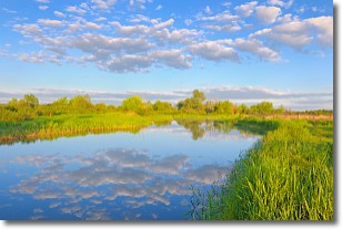
Weather Topic: What are Stratocumulus Clouds?
Home - Education - Cloud Types - Stratocumulus Clouds
 Next Topic: Stratus Clouds
Stratocumulus clouds are similar to altocumulus clouds in their
fluffy appearance, but have a slightly darker shade due to their additional mass.
A good way to distinguish the two cloud types is to hold your hand out and measure
the size of an individual cloud; if it is the size of your thumb it is generally
an altocumulus cloud, if it is the size of your hand it is generally a
stratocumulus cloud.
It is uncommon for stratocumulus clouds to produce precipitation, but if they do
it is usually a light rain or snow.
Next Topic: Stratus Clouds
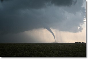
Weather Topic: What are Wall Clouds?
Home - Education - Cloud Types - Wall Clouds
 Next Topic: Altocumulus Clouds
A wall cloud forms underneath the base of a cumulonimbus cloud,
and can be a hotbed for deadly tornadoes.
Wall clouds are formed by air flowing into the cumulonimbus clouds, which can
result in the wall cloud descending from the base of the cumulonimbus cloud, or
rising fractus clouds which join to the base of the storm cloud as the wall cloud
takes shape.
Wall clouds can be very large, and in the Northern Hemisphere they generally
form at the southern edge of cumulonimbus clouds.
Next Topic: Altocumulus Clouds
Current conditions powered by WeatherAPI.com


