Weather Alert in Wisconsin
Flood Watch issued April 3 at 9:48PM CDT until April 6 at 4:00PM CDT by NWS Milwaukee/Sullivan WI
AREAS AFFECTED: Sauk, WI
DESCRIPTION: ...The National Weather Service in Milwaukee/Sullivan WI has issued a Flood Watch for the following rivers in Wisconsin... Baraboo River At Reedsburg affecting Sauk County. Baraboo River At Rock Springs affecting Sauk County. Baraboo River Near Baraboo affecting Columbia and Sauk Counties. * WHAT...Flooding is possible. * WHERE...Baraboo River at Reedsburg. * WHEN...From Saturday morning to Monday afternoon. * IMPACTS...At 16.0 feet, There is widespread inundation of lowland in the Reedsburg area. Floodwaters affect West Second Street, Granite Avenue and South Webb Avenue along the river. Water affects the concrete deck of the South Webb Avenue bridge. Floodwaters are into Webb Park and Smith Conservancy. The Public Works Yard is under 2 to 2.5 feet of water. * ADDITIONAL DETAILS... - At 9:00 PM CDT Friday the stage was 11.6 feet. - Forecast...Flood stage may be reached tomorrow morning. - Flood stage is 14.0 feet. - http://www.weather.gov/safety/flood
INSTRUCTION: If you are in the watch area, remain alert to possible flooding. Additional information is available at www.weather.gov. The next statement will be issued Saturday morning at 600 AM CDT.
Want more detail? Get the Complete 7 Day and Night Detailed Forecast!
Current U.S. National Radar--Current
The Current National Weather Radar is shown below with a UTC Time (subtract 5 hours from UTC to get Eastern Time).

National Weather Forecast--Current
The Current National Weather Forecast and National Weather Map are shown below.

National Weather Forecast for Tomorrow
Tomorrow National Weather Forecast and Tomorrow National Weather Map are show below.

North America Water Vapor (Moisture)
This map shows recent moisture content over North America. Bright and colored areas show high moisture (ie, clouds); brown indicates very little moisture present; black indicates no moisture.

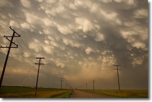
Weather Topic: What are Mammatus Clouds?
Home - Education - Cloud Types - Mammatus Clouds
 Next Topic: Nimbostratus Clouds
A mammatus cloud is a cloud with a unique feature which resembles
a web of pouches hanging along the base of the cloud.
In the United States, mammatus clouds tend to form in the warmer months, commonly
in the Midwest and eastern regions.
While they usually form at the bottom of a cumulonimbis cloud, they can also form
under altostratus, altocumulus, stratocumulus, and cirrus clouds. Mammatus clouds
warn that severe weather is close.
Next Topic: Nimbostratus Clouds
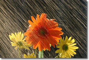
Weather Topic: What is Precipitation?
Home - Education - Precipitation - Precipitation
 Next Topic: Rain
Precipitation can refer to many different forms of water that
may fall from clouds. Precipitation occurs after a cloud has become saturated to
the point where its water particles are more dense than the air below the cloud.
In most cases, precipitation will reach the ground, but it is not uncommon for
precipitation to evaporate before it reaches the earth's surface.
When precipitation evaporates before it contacts the ground it is called Virga.
Graupel, hail, sleet, rain, drizzle, and snow are forms of precipitation, but fog
and mist are not considered precipitation because the water vapor which
constitutes them isn't dense enough to fall to the ground.
Next Topic: Rain
Current conditions powered by WeatherAPI.com


