Weather Alert in Arizona
Special Weather Statement issued August 14 at 11:25PM MST by NWS Phoenix AZ
AREAS AFFECTED: Cave Creek/New River; Deer Valley; North Phoenix/Glendale; New River Mesa; Scottsdale/Paradise Valley; Rio Verde/Salt River; East Valley; Fountain Hills/East Mesa; Southeast Valley/Queen Creek; Superior; Northwest Pinal County; Apache Junction/Gold Canyon; Mazatzal Mountains; Pinal/Superstition Mountains
DESCRIPTION: At 1120 PM MST, a cluster of thunderstorms continue to persist, with additional development across eastern portions of the Phoenix metro anticipated into the overnight hours. Wind gusts up to 50 mph will be possible, with frequent lightning and heavy downpours that could result in localized accumulations of one half inch or greater. Locations impacted include... Phoenix, Mesa, Chandler, Scottsdale, Gilbert, Tempe, Casa Grande, Apache Junction, Florence, Fountain Hills, Paradise Valley, Coolidge, Sycamore Creek, East Mesa, Sunflower, Gold Canyon, New River, Sugarloaf Mountain, Sun Lakes, and Ballantine Trailhead. This includes the following highways... AZ Interstate 10 between mile markers 170 and 204. AZ Interstate 17 between mile markers 219 and 241. AZ Interstate 8 between mile markers 172 and 178. If outdoors, consider seeking shelter inside a building. Torrential rainfall is also occurring with these storms, and may cause localized flooding. Do not drive your vehicle through flooded roadways. Frequent cloud to ground lightning is occurring with this storm. Lightning can strike 10 miles away from a thunderstorm. Seek a safe shelter inside a building or vehicle.
INSTRUCTION: N/A
Want more detail? Get the Complete 7 Day and Night Detailed Forecast!
Current U.S. National Radar--Current
The Current National Weather Radar is shown below with a UTC Time (subtract 5 hours from UTC to get Eastern Time).

National Weather Forecast--Current
The Current National Weather Forecast and National Weather Map are shown below.

National Weather Forecast for Tomorrow
Tomorrow National Weather Forecast and Tomorrow National Weather Map are show below.

North America Water Vapor (Moisture)
This map shows recent moisture content over North America. Bright and colored areas show high moisture (ie, clouds); brown indicates very little moisture present; black indicates no moisture.

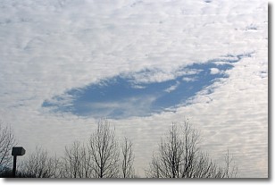
Weather Topic: What are Hole Punch Clouds?
Home - Education - Cloud Types - Hole Punch Clouds
 Next Topic: Mammatus Clouds
A hole punch cloud is an unusual occurrence when a disk-shaped
hole appears in a cirrostratus, cirrocumulus, or altocumulus cloud.
When part of the cloud forms ice crystals, water droplets in the surrounding area
of the cloud evaporate. The effect of this process produces a large elliptical
gap in the cloud. The hole punch cloud formation is rare, but it is not specific
to any geographic area.
Other names which have been used to describe this phenomena include fallstreak hole,
skypunch, and cloud hole.
Next Topic: Mammatus Clouds
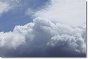
Weather Topic: What are Nimbostratus Clouds?
Home - Education - Cloud Types - Nimbostratus Clouds
 Next Topic: Precipitation
A nimbostratus cloud is similar to a stratus cloud in its formless,
smooth appearance. However, a nimbostratus cloud is darker than a stratus cloud,
because it is thicker.
Unlike a stratus cloud, a nimbostratus cloud typically brings with it the threat
of moderate to heavy precipitation. In some cases, the precipitation may evaporate
before reaching the ground, a phenomenon known as virga.
Next Topic: Precipitation
Current conditions powered by WeatherAPI.com


