Weather Alert in Idaho
Red Flag Warning issued August 14 at 9:33PM MDT until August 15 at 9:00PM MDT by NWS Pocatello ID
AREAS AFFECTED: Caribou Range/Caribou NF; Goose Creek and Raft River Valley/Southern Sawtooth NF/Twin Falls BLM south of the Snake River
DESCRIPTION: The National Weather Service in Pocatello has issued a Red Flag Warning for scattered thunderstorms, which is in effect from noon to 9 PM MDT Friday. * AFFECTED AREA...Fire Weather Zone 413 Caribou Range/Caribou NF and Fire Weather Zone 427 Goose Creek and Raft River Valley/Southern Sawtooth NF/Twin Falls BLM south of the Snake River. * THUNDERSTORMS...25 to 45 percent coverage. * OUTFLOW WINDS...A dry low level environment will promote stronger storms capable of producing wind gusts up to 55 mph. * IMPACTS...Critical fire weather conditions are expected Friday afternoon and evening. Lightning may generate new fire starts. Any new fire starts or existing fires may spread rapidly.
INSTRUCTION: A Red Flag Warning means that critical fire weather conditions are either occurring now, or will shortly based on these criteria for Southeastern Idaho: - Relative humidity at or below 15 percent and wind gusts of at least 25 mph in the mountains, or 30 mph in the Snake Plain. - Thunderstorm coverage of 25 percent, without specific rainfall criteria. - Other high impact events deemed critical by the National Weather Service and area fire management agencies.
Want more detail? Get the Complete 7 Day and Night Detailed Forecast!
Current U.S. National Radar--Current
The Current National Weather Radar is shown below with a UTC Time (subtract 5 hours from UTC to get Eastern Time).

National Weather Forecast--Current
The Current National Weather Forecast and National Weather Map are shown below.

National Weather Forecast for Tomorrow
Tomorrow National Weather Forecast and Tomorrow National Weather Map are show below.

North America Water Vapor (Moisture)
This map shows recent moisture content over North America. Bright and colored areas show high moisture (ie, clouds); brown indicates very little moisture present; black indicates no moisture.

Weather Topic: What are Fractus Clouds?
Home - Education - Cloud Types - Fractus Clouds
 Next Topic: Freezing Rain
A fractus cloud (scud) is a fragmented, tattered cloud which has
likely been sheared off of another cloud. They are accessory clouds, meaning they
develop from parent clouds, and are named in a way which describes the original
cloud which contained them.
Fractus clouds which have originated from cumulus clouds are referred to as
cumulus fractus, while fractus clouds which have originated from stratus clouds
are referred to as stratus fractus. Under certain conditions a fractus cloud might
merge with another cloud, or develop into a cumulus cloud, but usually a
fractus cloud seen by itself will dissipate rapidly.
They are often observed on the leading and trailing edges of storm clouds,
and are a display of wind activity.
Next Topic: Freezing Rain
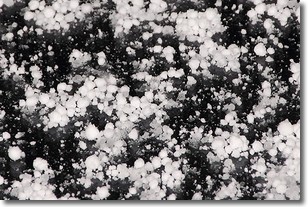
Weather Topic: What is Graupel?
Home - Education - Precipitation - Graupel
 Next Topic: Hail
Graupel is a form of precipitation that is created by atmospheric conditions
which cause supercooled water droplets to contact snow crystals and freeze to
their surface.
Sometimes known as soft hail or snow pellets, graupel is delicate and easily
destroyed by touch. Whereas hail usually falls during severe weather, graupel
doesn't require such conditions to form, and can form in mild precipitation
similar to situations which produce snowfall.
Next Topic: Hail
Current conditions powered by WeatherAPI.com


