Weather Alert in Michigan
Hydrologic Outlook issued April 4 at 2:12PM EDT by NWS Grand Rapids MI
AREAS AFFECTED: Allegan, MI; Barry, MI; Calhoun, MI; Clare, MI; Clinton, MI; Eaton, MI; Gratiot, MI; Ingham, MI; Ionia, MI; Isabella, MI; Jackson, MI; Kalamazoo, MI; Kent, MI; Lake, MI; Mason, MI; Mecosta, MI; Montcalm, MI; Muskegon, MI; Newaygo, MI; Oceana, MI; Osceola, MI; Ottawa, MI; Van Buren, MI
DESCRIPTION: ESFGRR Rainfall totals of 1-3 inches across the area this morning led to areas of areal flooding and ponding on roads, particularly for the Lansing area and Mount Pleasant areas. Additional rainfall to around 0.25" is expected through this evening for most, though totals to around 1" are possible for areas south and east of a Grand Rapids to Alma line in any thunderstorms this afternoon. This will likely slow drainage of ongoing flooding, and may result in the need for additional flood advisories if thunderstorms track over flood prone areas. Many area rivers and streams have seen rises as a result of the heavy rainfall. River Flood Warnings and Watches are in effect for numerous river forecast points across the area as the waters make their way through our river systems. Refer to those products for the latest information on river flooding. Numerous others are forecast to reach bankfull, with the Muskegon River at Evart coming particularly close to minor flood stage. For any type of flooding, avoid driving through flood waters. Turn around, don't drown!
INSTRUCTION: N/A
Want more detail? Get the Complete 7 Day and Night Detailed Forecast!
Current U.S. National Radar--Current
The Current National Weather Radar is shown below with a UTC Time (subtract 5 hours from UTC to get Eastern Time).

National Weather Forecast--Current
The Current National Weather Forecast and National Weather Map are shown below.

National Weather Forecast for Tomorrow
Tomorrow National Weather Forecast and Tomorrow National Weather Map are show below.

North America Water Vapor (Moisture)
This map shows recent moisture content over North America. Bright and colored areas show high moisture (ie, clouds); brown indicates very little moisture present; black indicates no moisture.

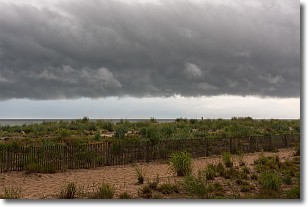
Weather Topic: What are Shelf Clouds?
Home - Education - Cloud Types - Shelf Clouds
 Next Topic: Sleet
A shelf cloud is similar to a wall cloud, but forms at the front
of a storm cloud, instead of at the rear, where wall clouds form.
A shelf cloud is caused by a series of events set into motion by the advancing
storm; first, cool air settles along the ground where precipitation has just fallen.
As the cool air is brought in, the warmer air is displaced, and rises above it,
because it is less dense. When the warmer air reaches the bottom of the storm cloud,
it begins to cool again, and the resulting condensation is a visible shelf cloud.
Next Topic: Sleet
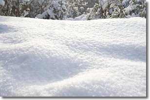
Weather Topic: What is Snow?
Home - Education - Precipitation - Snow
 Next Topic: Stratocumulus Clouds
Snow is precipitation taking the form of ice crystals. Each ice crystal, or snowflake,
has unique characteristics, but all of them grow in a hexagonal structure.
Snowfall can last for sustained periods of time and result in significant buildup
of snow on the ground.
On the earth's surface, snow starts out light and powdery, but as it begins to melt
it tends to become more granular, producing small bits of ice which have the consistency of
sand. After several cycles of melting and freezing, snow can become very dense
and ice-like, commonly known as snow pack.
Next Topic: Stratocumulus Clouds
Current conditions powered by WeatherAPI.com


