Weather Alert in South Carolina
Flood Warning issued August 15 at 11:58AM EDT until August 19 at 4:24AM EDT by NWS Columbia SC
AREAS AFFECTED: Calhoun, SC; Richland, SC
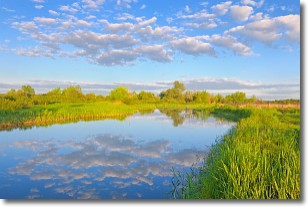
DESCRIPTION: ...The Flood Warning is extended for the following rivers in South Carolina... Congaree River At Congaree River at Congaree NP Near Gadsden affecting Calhoun and Richland Counties. Congaree River At Carolina Eastman affecting Richland, Calhoun and Lexington Counties. * WHAT...Minor flooding is occurring and minor flooding is forecast. * WHERE...Congaree River at Congaree River at Congaree NP Near Gadsden. * WHEN...Until early Tuesday morning. * IMPACTS...At 15.0 feet, Flooding begins in the Congaree National Park. This will begin to produce flooding of portions of the lower boardwalk. At 17.0 feet, The access road to the Sandy Run subdivision becomes flooded. The lower boardwalk in the Congaree National Park becomes flooded by Cedar Creek. At 18.0 feet, Several homes in the Sandy Run subdivision along the river become flooded. At 18 feet the river covers the Weston Lake overlook in the Congaree National Park. Between 18 and 18.5 feet the river begins to cover sections of the elevated boardwalk. * ADDITIONAL DETAILS... - At 11:00 AM EDT Friday the stage was 16.8 feet. - Bankfull stage is 14.0 feet. - Recent Activity...The maximum river stage in the 24 hours ending at 11:00 AM EDT Friday was 17.2 feet. - Forecast...The river is expected to fall below flood stage early Monday morning and continue falling to 10.6 feet Wednesday morning. - Flood stage is 15.0 feet. - http://www.weather.gov/safety/flood
INSTRUCTION: Residents and those with interests near the river should monitor rising water levels and take action if necessary. Caution is urged when walking near riverbanks. Additional information is available at www.weather.gov. The next statement will be issued late tonight at midnight EDT.
Want more detail? Get the Complete 7 Day and Night Detailed Forecast!
Current U.S. National Radar--Current
The Current National Weather Radar is shown below with a UTC Time (subtract 5 hours from UTC to get Eastern Time).

National Weather Forecast--Current
The Current National Weather Forecast and National Weather Map are shown below.

National Weather Forecast for Tomorrow
Tomorrow National Weather Forecast and Tomorrow National Weather Map are show below.

North America Water Vapor (Moisture)
This map shows recent moisture content over North America. Bright and colored areas show high moisture (ie, clouds); brown indicates very little moisture present; black indicates no moisture.

Weather Topic: What are Stratocumulus Clouds?
Home - Education - Cloud Types - Stratocumulus Clouds
 Next Topic: Stratus Clouds
Stratocumulus clouds are similar to altocumulus clouds in their
fluffy appearance, but have a slightly darker shade due to their additional mass.
A good way to distinguish the two cloud types is to hold your hand out and measure
the size of an individual cloud; if it is the size of your thumb it is generally
an altocumulus cloud, if it is the size of your hand it is generally a
stratocumulus cloud.
It is uncommon for stratocumulus clouds to produce precipitation, but if they do
it is usually a light rain or snow.
Next Topic: Stratus Clouds
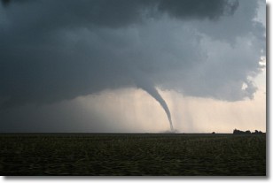
Weather Topic: What are Wall Clouds?
Home - Education - Cloud Types - Wall Clouds
 Next Topic: Altocumulus Clouds
A wall cloud forms underneath the base of a cumulonimbus cloud,
and can be a hotbed for deadly tornadoes.
Wall clouds are formed by air flowing into the cumulonimbus clouds, which can
result in the wall cloud descending from the base of the cumulonimbus cloud, or
rising fractus clouds which join to the base of the storm cloud as the wall cloud
takes shape.
Wall clouds can be very large, and in the Northern Hemisphere they generally
form at the southern edge of cumulonimbus clouds.
Next Topic: Altocumulus Clouds
Current conditions powered by WeatherAPI.com


