Weather Alert in New York
Flood Advisory issued April 3 at 1:50PM EDT until April 4 at 2:00AM EDT by NWS Buffalo NY
AREAS AFFECTED: Oswego, NY
DESCRIPTION: * WHAT...Flooding caused by excessive rainfall continues along the Salmon River. * WHERE...A portion of central New York, including the following county, Oswego. * WHEN...Until 200 AM EDT Saturday. * IMPACTS...Minor flooding in low-lying areas along the Salmon River will continue through this evening. Fisherman should avoid the river with high flows creating dangerous conditions. * ADDITIONAL DETAILS... - At 144 PM EDT, gauge reports indicated high flows on the Salmon River resulting from recent heavy rainfall and snowmelt from the Tug Hill Plateau. - Some locations that will experience flooding include... Areas along the Salmon River from Altmar downstream through Pulaski to the mouth at Lake Ontario. - http://www.weather.gov/safety/flood
INSTRUCTION: Turn around, don't drown when encountering flooded roads. Most flood deaths occur in vehicles.
Want more detail? Get the Complete 7 Day and Night Detailed Forecast!
Current U.S. National Radar--Current
The Current National Weather Radar is shown below with a UTC Time (subtract 5 hours from UTC to get Eastern Time).

National Weather Forecast--Current
The Current National Weather Forecast and National Weather Map are shown below.

National Weather Forecast for Tomorrow
Tomorrow National Weather Forecast and Tomorrow National Weather Map are show below.

North America Water Vapor (Moisture)
This map shows recent moisture content over North America. Bright and colored areas show high moisture (ie, clouds); brown indicates very little moisture present; black indicates no moisture.

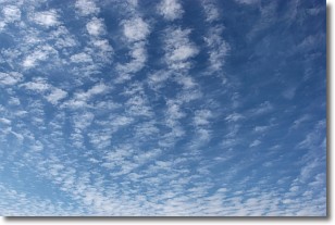
Weather Topic: What are Cirrocumulus Clouds?
Home - Education - Cloud Types - Cirrocumulus Clouds
 Next Topic: Cirrostratus Clouds
Cirrocumulus clouds form at high altitudes (usually around 5 km)
and have distinguishing characteristics displayed in a fine layer of
small cloud patches. These small cloud patches are sometimes referred to as
"cloudlets" in relation to the whole cloud formation.
Cirrocumulus clouds are formed from ice crystals and water droplets. Often, the
water droplets in the cloud freeze into ice crystals and the cloud becomes a
cirrostratus cloud. Because of this common occurrence, cirrocumulus cloud
formations generally pass rapidly.
Next Topic: Cirrostratus Clouds
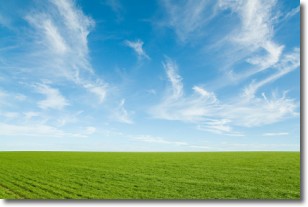
Weather Topic: What are Cirrus Clouds?
Home - Education - Cloud Types - Cirrus Clouds
 Next Topic: Condensation
Cirrus clouds are high-level clouds that occur above 20,000 feet
and are composed mainly of ice crystals.
They are thin and wispy in appearance.
What do they indicate?
They are often the first sign of an approaching storm.
Next Topic: Condensation
Current conditions powered by WeatherAPI.com


