Weather Alert in North Carolina
Extreme Heat Warning issued June 24 at 10:01AM EDT until June 25 at 8:00PM EDT by NWS Newport/Morehead City NC
AREAS AFFECTED: Martin; Pitt; Washington; Tyrrell; Mainland Dare; Greene; Beaufort; Mainland Hyde; Duplin; Lenoir; Jones; Pamlico; Northern Craven; Southern Craven; West Carteret; East Carteret; Inland Onslow; Coastal Onslow; Northern Outer Banks; Ocracoke Island; Hatteras Island
DESCRIPTION: * WHAT...Dangerously hot conditions with heat index values of 110 to 115 expected. * WHERE...A portion of eastern North Carolina. * WHEN...Until 8 PM EDT Wednesday. * IMPACTS...Heat related illnesses increase significantly during extreme heat and high humidity events. * ADDITIONAL DETAILS...A dangerous, and longer-lasting, heatwave will continue to impact all of ENC through the middle of this week. The cumulative impact of the heat, along with little relief at night, will magnify the level of impact.
INSTRUCTION: Do not leave young children and pets in unattended vehicles. Car interiors will reach lethal temperatures in a matter of minutes. To reduce risk during outdoor work, the Occupational Safety and Health Administration recommends scheduling frequent rest breaks in shaded or air conditioned environments. Anyone overcome by heat should be moved to a cool and shaded location. Heat stroke is an emergency! Call 9 1 1.
Want more detail? Get the Complete 7 Day and Night Detailed Forecast!
Current U.S. National Radar--Current
The Current National Weather Radar is shown below with a UTC Time (subtract 5 hours from UTC to get Eastern Time).

National Weather Forecast--Current
The Current National Weather Forecast and National Weather Map are shown below.

National Weather Forecast for Tomorrow
Tomorrow National Weather Forecast and Tomorrow National Weather Map are show below.

North America Water Vapor (Moisture)
This map shows recent moisture content over North America. Bright and colored areas show high moisture (ie, clouds); brown indicates very little moisture present; black indicates no moisture.

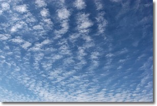
Weather Topic: What are Altocumulus Clouds?
Home - Education - Cloud Types - Altocumulus Clouds
 Next Topic: Altostratus Clouds
Similar to cirrocumulus clouds, altocumulus clouds are
characterized by cloud patches. They are distinguished by larger cloudlets
than cirrocumulus clouds but are still smaller than stratocumulus clouds.
Altocumulus clouds most commonly form in middle altitudes (between 2 and 5 km)
and may resemble, at times, the shape of a flying saucer.
These uncommon formations, called altocumulus lenticularis, are created by uplift
in the atmosphere and are most often seen in close proximity to mountains.
Next Topic: Altostratus Clouds
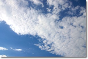
Weather Topic: What are Cirrocumulus Clouds?
Home - Education - Cloud Types - Cirrocumulus Clouds
 Next Topic: Cirrostratus Clouds
Cirrocumulus clouds form at high altitudes (usually around 5 km)
and have distinguishing characteristics displayed in a fine layer of
small cloud patches. These small cloud patches are sometimes referred to as
"cloudlets" in relation to the whole cloud formation.
Cirrocumulus clouds are formed from ice crystals and water droplets. Often, the
water droplets in the cloud freeze into ice crystals and the cloud becomes a
cirrostratus cloud. Because of this common occurrence, cirrocumulus cloud
formations generally pass rapidly.
Next Topic: Cirrostratus Clouds
Current conditions powered by WeatherAPI.com


