Weather Alert in Texas
Flood Warning issued June 23 at 7:49PM CDT by NWS Houston/Galveston TX
AREAS AFFECTED: Polk, TX; San Jacinto, TX; Trinity, TX; Walker, TX
DESCRIPTION: ...The Flood Warning continues for the following rivers in Texas... Trinity River at Riverside affecting San Jacinto, Polk, Walker and Trinity Counties. Trinity River at Liberty affecting Liberty County. Trinity River near Moss Bluff affecting Chambers and Liberty Counties. For the Trinity River...including Riverside, Moss Bluff, Liberty... Major flooding is forecast. * WHAT...Moderate flooding is occurring and moderate flooding is forecast. * WHERE...Trinity River at Riverside. * WHEN...Until further notice. * IMPACTS...At 137.0 feet, Moderate lowland flooding continues as several homes in the Green Rich Shores Subdivision in Walker County flood and water covers Thomas Lake Road. The lowest buildings off FM 980 northwest of Riverside flood. At 138.0 feet, Moderate lowland flooding continues with water 3 to 4 feet below the State Highway 19 Bridge and Plantation Drive near FM 230 is inundated. FM 2978 is flooded and impassable. Up to one foot of water is flowing over Thomas Lake Road which remains impassable. Several roads into the Green Rich Shores and Deep River Plantation subdivisions are covered with up to one foot of water and homes in Deep River Plantation are threatened. * ADDITIONAL DETAILS... - At 7:30 PM CDT Monday the stage was 137.6 feet. - Bankfull stage is 133.0 feet. - Recent Activity...The maximum river stage in the 24 hours ending at 7:30 PM CDT Monday was 137.8 feet. - Forecast...The river is expected to rise to a crest of 137.6 feet just after midnight tonight. - Flood stage is 133.5 feet. - Flood History...This crest compares to a previous crest of 137.6 feet on 05/11/1944. - http://www.weather.gov/safety/flood
INSTRUCTION: Turn around, don't drown when encountering flooded roads. Most flood deaths occur in vehicles. Motorists should not attempt to drive around barricades or drive cars through flooded areas. Additional information is available at www.weather.gov/hgx. The next statement will be issued by Tuesday afternoon at 200 PM CDT.
Want more detail? Get the Complete 7 Day and Night Detailed Forecast!
Current U.S. National Radar--Current
The Current National Weather Radar is shown below with a UTC Time (subtract 5 hours from UTC to get Eastern Time).

National Weather Forecast--Current
The Current National Weather Forecast and National Weather Map are shown below.

National Weather Forecast for Tomorrow
Tomorrow National Weather Forecast and Tomorrow National Weather Map are show below.

North America Water Vapor (Moisture)
This map shows recent moisture content over North America. Bright and colored areas show high moisture (ie, clouds); brown indicates very little moisture present; black indicates no moisture.

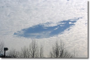
Weather Topic: What are Hole Punch Clouds?
Home - Education - Cloud Types - Hole Punch Clouds
 Next Topic: Mammatus Clouds
A hole punch cloud is an unusual occurrence when a disk-shaped
hole appears in a cirrostratus, cirrocumulus, or altocumulus cloud.
When part of the cloud forms ice crystals, water droplets in the surrounding area
of the cloud evaporate. The effect of this process produces a large elliptical
gap in the cloud. The hole punch cloud formation is rare, but it is not specific
to any geographic area.
Other names which have been used to describe this phenomena include fallstreak hole,
skypunch, and cloud hole.
Next Topic: Mammatus Clouds
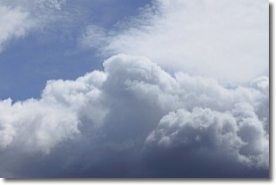
Weather Topic: What are Nimbostratus Clouds?
Home - Education - Cloud Types - Nimbostratus Clouds
 Next Topic: Precipitation
A nimbostratus cloud is similar to a stratus cloud in its formless,
smooth appearance. However, a nimbostratus cloud is darker than a stratus cloud,
because it is thicker.
Unlike a stratus cloud, a nimbostratus cloud typically brings with it the threat
of moderate to heavy precipitation. In some cases, the precipitation may evaporate
before reaching the ground, a phenomenon known as virga.
Next Topic: Precipitation
Current conditions powered by WeatherAPI.com


