Weather Alert in Illinois
Flood Warning issued April 3 at 11:05AM CDT until April 5 at 10:00AM CDT by NWS Chicago IL
AREAS AFFECTED: La Salle, IL
DESCRIPTION: ...The Flood Warning is extended for the following rivers in Illinois... Fox River at Dayton affecting La Salle County. For the Fox River (Illinois)...including Dayton...Minor flooding is forecast. * WHAT...Minor flooding is occurring and minor flooding is forecast. * WHERE...Fox River from Millington downstream to confluence with the Illinois River, including the Dayton gauge. * WHEN...From this morning to late Sunday morning. * IMPACTS...At 12.5 feet, 2062nd Road threatened in Wedron. Low-lying agricultural land inundated near Wedron. * ADDITIONAL DETAILS... - At 10:45 AM CDT Friday the stage was 12.0 feet. - Recent Activity...The maximum river stage in the 24 hours ending at 10:45 AM CDT Friday was 12.0 feet. - Forecast...The river is expected to rise to a crest of 12.7 feet just after midnight tonight. It will then fall below flood stage early Sunday morning. - Flood stage is 12.0 feet. - http://www.weather.gov/safety/flood
INSTRUCTION: A Flood Warning means water levels above flood stage are imminent or may already be occurring. Persons along rivers and streams in the warned area should take immediate precautions to protect life and property. These forecasts are based on observed precipitation as well as forecast precipitation 24 hours into the future. Changes to the rainfall forecast, or any additional rainfall after 24 hours, may cause changes to these river forecasts. Additional information is available at www.weather.gov. The next statement will be issued by late tonight.
Want more detail? Get the Complete 7 Day and Night Detailed Forecast!
Current U.S. National Radar--Current
The Current National Weather Radar is shown below with a UTC Time (subtract 5 hours from UTC to get Eastern Time).

National Weather Forecast--Current
The Current National Weather Forecast and National Weather Map are shown below.

National Weather Forecast for Tomorrow
Tomorrow National Weather Forecast and Tomorrow National Weather Map are show below.

North America Water Vapor (Moisture)
This map shows recent moisture content over North America. Bright and colored areas show high moisture (ie, clouds); brown indicates very little moisture present; black indicates no moisture.

Weather Topic: What are Fractus Clouds?
Home - Education - Cloud Types - Fractus Clouds
 Next Topic: Freezing Rain
A fractus cloud (scud) is a fragmented, tattered cloud which has
likely been sheared off of another cloud. They are accessory clouds, meaning they
develop from parent clouds, and are named in a way which describes the original
cloud which contained them.
Fractus clouds which have originated from cumulus clouds are referred to as
cumulus fractus, while fractus clouds which have originated from stratus clouds
are referred to as stratus fractus. Under certain conditions a fractus cloud might
merge with another cloud, or develop into a cumulus cloud, but usually a
fractus cloud seen by itself will dissipate rapidly.
They are often observed on the leading and trailing edges of storm clouds,
and are a display of wind activity.
Next Topic: Freezing Rain
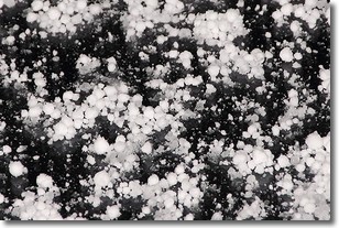
Weather Topic: What is Graupel?
Home - Education - Precipitation - Graupel
 Next Topic: Hail
Graupel is a form of precipitation that is created by atmospheric conditions
which cause supercooled water droplets to contact snow crystals and freeze to
their surface.
Sometimes known as soft hail or snow pellets, graupel is delicate and easily
destroyed by touch. Whereas hail usually falls during severe weather, graupel
doesn't require such conditions to form, and can form in mild precipitation
similar to situations which produce snowfall.
Next Topic: Hail
Current conditions powered by WeatherAPI.com


