Weather Alert in California
Coastal Flood Advisory issued June 24 at 11:15AM PDT until June 25 at 1:00AM PDT by NWS Eureka CA
AREAS AFFECTED: Northern Humboldt Coast
DESCRIPTION: * WHAT...High astronomical tides will cause minor flooding in low lying areas around Humboldt Bay. Up to one quarter foot of saltwater inundation above ground level is possible near shorelines and tidal waterways. Between 8.6 and 8.9 feet MLLW at the North Spit tide gauge is predicted. * WHERE...Northern Humboldt Coast County. * WHEN...From 9 PM this evening to 1 AM PDT Wednesday. High tide is at 11:06 PM at the Humboldt Bay North Spit tide gauge. Saltwater inundation will be possible 1 to 2 hours before and after high tide. * IMPACTS...Flooding of low lying areas around Humboldt Bay including parks and roads with only isolated closures expected. Flooding could impact Jackson Ranch Road in the Arcata Bottoms and several roads in King Salmon.
INSTRUCTION: A Coastal Flood Advisory indicates that onshore winds and tides will combine to generate flooding of low areas along the shore. Feet Above Ground is locally defined as feet above the Highest Astronomical Tide or HAT.
Want more detail? Get the Complete 7 Day and Night Detailed Forecast!
Current U.S. National Radar--Current
The Current National Weather Radar is shown below with a UTC Time (subtract 5 hours from UTC to get Eastern Time).

National Weather Forecast--Current
The Current National Weather Forecast and National Weather Map are shown below.

National Weather Forecast for Tomorrow
Tomorrow National Weather Forecast and Tomorrow National Weather Map are show below.

North America Water Vapor (Moisture)
This map shows recent moisture content over North America. Bright and colored areas show high moisture (ie, clouds); brown indicates very little moisture present; black indicates no moisture.

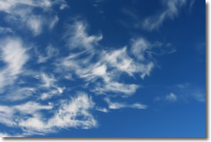
Weather Topic: What are Cirrostratus Clouds?
Home - Education - Cloud Types - Cirrostratus Clouds
 Next Topic: Cirrus Clouds
Cirrostratus clouds are high, thin clouds that form above
20,000 feet and are made mostly of ice crystals. They sometimes look like giant
feathers, horse tails, or curls of hair in the sky.
These clouds are pushed by the jet stream and can move at high speeds reaching
100 mph.
What do they indicate?
They indicate that a precipitation is likely within 24 hours.
Next Topic: Cirrus Clouds
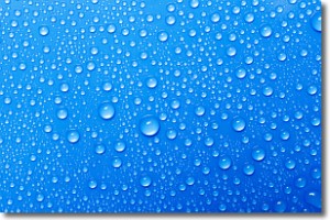
Weather Topic: What is Condensation?
Home - Education - Precipitation - Condensation
 Next Topic: Contrails
Condensation is the process which creates clouds, and therefore
it is a crucial process in the water cycle.
Condensation is the change of matter from a state of gas into a state of liquid,
and it happens because water molecules release heat into the atmosphere and
become organized into a more closely packed structure, what we might see as
water droplets.
Water is always present in the air around us as a vapor, but it's too small for
us to see. When water undergoes the process of condensation it becomes organized
into visible water droplets. You've probably seen condensation happen before on the
surface of a cold drink!
Next Topic: Contrails
Current conditions powered by WeatherAPI.com


