Weather Alert in California
Coastal Flood Advisory issued June 24 at 11:15AM PDT until June 25 at 1:00AM PDT by NWS Eureka CA
AREAS AFFECTED: Northern Humboldt Coast
DESCRIPTION: * WHAT...High astronomical tides will cause minor flooding in low lying areas around Humboldt Bay. Up to one quarter foot of saltwater inundation above ground level is possible near shorelines and tidal waterways. Between 8.6 and 8.9 feet MLLW at the North Spit tide gauge is predicted. * WHERE...Northern Humboldt Coast County. * WHEN...From 9 PM this evening to 1 AM PDT Wednesday. High tide is at 11:06 PM at the Humboldt Bay North Spit tide gauge. Saltwater inundation will be possible 1 to 2 hours before and after high tide. * IMPACTS...Flooding of low lying areas around Humboldt Bay including parks and roads with only isolated closures expected. Flooding could impact Jackson Ranch Road in the Arcata Bottoms and several roads in King Salmon.
INSTRUCTION: A Coastal Flood Advisory indicates that onshore winds and tides will combine to generate flooding of low areas along the shore. Feet Above Ground is locally defined as feet above the Highest Astronomical Tide or HAT.
Want more detail? Get the Complete 7 Day and Night Detailed Forecast!
Current U.S. National Radar--Current
The Current National Weather Radar is shown below with a UTC Time (subtract 5 hours from UTC to get Eastern Time).

National Weather Forecast--Current
The Current National Weather Forecast and National Weather Map are shown below.

National Weather Forecast for Tomorrow
Tomorrow National Weather Forecast and Tomorrow National Weather Map are show below.

North America Water Vapor (Moisture)
This map shows recent moisture content over North America. Bright and colored areas show high moisture (ie, clouds); brown indicates very little moisture present; black indicates no moisture.

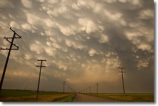
Weather Topic: What are Mammatus Clouds?
Home - Education - Cloud Types - Mammatus Clouds
 Next Topic: Nimbostratus Clouds
A mammatus cloud is a cloud with a unique feature which resembles
a web of pouches hanging along the base of the cloud.
In the United States, mammatus clouds tend to form in the warmer months, commonly
in the Midwest and eastern regions.
While they usually form at the bottom of a cumulonimbis cloud, they can also form
under altostratus, altocumulus, stratocumulus, and cirrus clouds. Mammatus clouds
warn that severe weather is close.
Next Topic: Nimbostratus Clouds
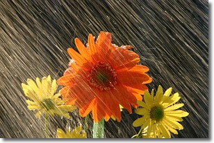
Weather Topic: What is Precipitation?
Home - Education - Precipitation - Precipitation
 Next Topic: Rain
Precipitation can refer to many different forms of water that
may fall from clouds. Precipitation occurs after a cloud has become saturated to
the point where its water particles are more dense than the air below the cloud.
In most cases, precipitation will reach the ground, but it is not uncommon for
precipitation to evaporate before it reaches the earth's surface.
When precipitation evaporates before it contacts the ground it is called Virga.
Graupel, hail, sleet, rain, drizzle, and snow are forms of precipitation, but fog
and mist are not considered precipitation because the water vapor which
constitutes them isn't dense enough to fall to the ground.
Next Topic: Rain
Current conditions powered by WeatherAPI.com


